Category:Apothekersdijk 37, Leiden
Jump to navigation
Jump to search
| Object location | | View all coordinates using: OpenStreetMap |
|---|
building in Leiden, Netherlands  | |||||
| Upload media | |||||
| Instance of | |||||
|---|---|---|---|---|---|
| Location | Leiden, South Holland, Netherlands | ||||
| Street address |
| ||||
| Located on street | |||||
| Heritage designation |
| ||||
 | |||||
|
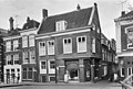
This is a category about rijksmonument number 24565
|
| Address |
|
Subcategories
This category has only the following subcategory.
I
Media in category "Apothekersdijk 37, Leiden"
The following 5 files are in this category, out of 5 total.
-
 Leiden - Apothekersdijk 37 - RM24565.jpg 2,736 × 3,648; 4.72 MB
-
 Overzicht van de hoek met deur - Leiden - 20426211 - RCE.jpg 800 × 1,200; 217 KB
-
 Overzicht van de voorgevel - Leiden - 20426208 - RCE.jpg 1,200 × 800; 204 KB
-
 Overzicht van de voorgevel en zijgevel - Leiden - 20426209 - RCE.jpg 800 × 1,200; 190 KB
-
 Voorgevel - Leiden - 20135590 - RCE.jpg 1,200 × 809; 225 KB


